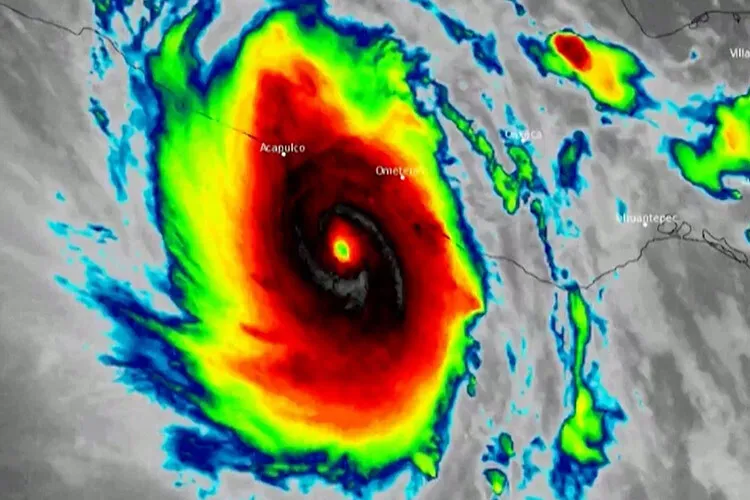
Hurricane Otis caused damage, flooding, and landslides in the hotel zone of Acapulco in Mexico on Wednesday, October 25, while it continued to move inland with heavy rainfall and strong winds.
But what is going on with hurricanes? Antonio Ruiz de Elvira Serra, Professor of Applied Physics at the University of Alcalá, reflected on the force with which Ian arrived in the United States in 2022 and how climate change affects hurricanes.
Here’s how the incredible force of a hurricane sucks the sea inland
After devastating Cuba and Florida, Hurricane Ian is heading towards North and South Carolina. In addition to strong winds and rain, tropical storms cause another phenomenon with a high potential for destruction along the coastline: storm surges.
Storms in general, and more specifically hurricanes, produce stronger winds when there is a greater difference in pressure between their inside and outside.
We can give an example to further understand this: when we blow hard into a tube we increase the air pressure at one end, which is why liquid shoots out if we blow into a straw, and which is why blowguns work.
A cyclone is an area of low pressure. The apparent Coriolis force (the Earth’s rotation on its axis) forces the air to rotate around the center of the storm. In the Northern Hemisphere, it does so counterclockwise because air is directed from a high-pressure area to a low-pressure area.
When the storm is over the sea, the wind acts upon the water’s surface, dragging it a little in the opposite direction to which it is blowing. This drag accumulates water as the storm progresses.
When the hurricane makes landfall, the accumulated water hits the coast. If it consists of a gentle continental shelf, i.e., if the beach slopes into the water without an abrupt drop, the rise of water dragged by the storm, which has turned into a hurricane or cyclone, penetrates many meters from the coastline. If, on the other hand, the continental shelf consists of a sharp drop, the water crashes and flows back. In extreme cases, cliffs prevent water from moving inland.

Coastal Destruction
In the United States, coasts on the Gulf of Mexico, Georgia, and North and South Carolina are very shallow, and hurricanes cause widespread storm surges that lead to extensive damage. If these surges occur at high tide, the effects can be magnified. Hurricane Katrina, which hit the area surrounding New Orleans in 2005, caused around 1,500 deaths and around 75 billion dollars in damage due, essentially, to the storm surge. During Katrina, the sea level rose about 8.5 meters, around the size of a three-story building.
In South Carolina, whose continental shelf is gently sloping, Ian could produce strong storm surges.
These swells are often combined with large waves. Waves are produced by air pressure oscillations as they pass over an initially undulating surface thanks to a small fluctuation that is amplified as long as the wind lasts. The highest waves recorded in the open ocean, without obstacles on the bottom, reach 20 meters high, and they repeat themselves as a periodic phenomenon.
Hurricanes combine heavy rain, high waves, and storm surge. They are immensely destructive to life in coastal areas prone to them. These areas are concentrated in warm water regions near the tropic lines.
How Hurricanes and Cyclones are Formed
In late summer and autumn in the Northern Hemisphere, tropical waters remain very warm.
Storms originating in the equatorial Atlantic and Pacific move northward, collapse on top of each other, and are magnified.
Convection occurs by having warm water on the surface of the sea. When the water rises in the atmosphere in the form of vapor, it cools and condenses and generates an enormous amount of heat that fuels the storm, which gradually grows until it forms a hurricane (as they’re known in America) or a tropical cyclone (in Asia).
Very warm water is needed at the surface below a tropical storm. This is why they form predominantly in the Caribbean and the China Sea, affecting the Caribbean islands, Mesoamerica, Mexico, and the United States as hurricanes, and the Philippines, the coasts of China, and Taiwan and Japan as cyclones.
Hurricanes could begin to affect the Canary Islands, but it’s difficult for them to impact continental European coasts as hurricanes because the sea is cold. Within the Mediterranean, with waters as warm as in the Caribbean, there isn’t enough space for the necessary amplification. In this sea, there’ll be increasingly intense storms, but they won’t reach the hurricane category.
Climate change doesn’t currently affect the number of hurricanes and cyclones that occur annually, but it does affect their intensity, which is growing with rising water temperatures.
It also affects the average sea level. An increase of just 10 centimeters would mean an influx of water from waves and swells of at least a kilometer inland if the land is flat, such as in the Gulf of Cádiz or in the Plain of Valencia, and considerable damage to building foundations and coastal infrastructure.
Increasing tropical storm damage is one more damaging effect we’re inflicting upon ourselves with global warming. (The Conversation / Reuters)
